
Landscape Structure Changes Assessment to Monitor Green Spaces in Mueang District, Amnatchaoen Province
DOI:
https://doi.org/10.34044/tferj.2025.9.1.6261Keywords:
Landscape Ecology, Landscape Mosaic, Urban Landscape, Land Cover Change, Geo-information TechnologyAbstract
Background and Objectives: Urbanization refers to the change of both physical and human landscape structures within an area in response to socio-economic development. This transformation leads to a reduction in urban open spaces, alongside the expansion of diverse land uses into peri-urban areas, contributing to the decline of green spaces in both urban and rural environments. This research aims to assess the changes in landscape ecological structures during the period from 2011 to 2022 by monitoring the diversity of land cover types using the Landscape Mosaic (LM) model and the LM-Anthropic model to describe the main structures and continuity of landscape components, including developed areas, agricultural areas, natural areas, and mixed-use areas, in order to evaluate the condition of green spaces in Mueang District, Amnat Charoen Province.
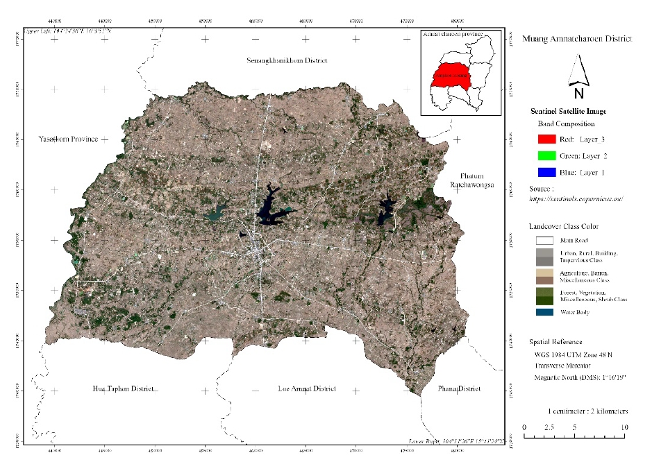
Methodology: This study applies geo-information technology to classify green and non-green areas based on Sentinel-2A satellite imagery, in conjunction with various indices, including the Normalized Difference Vegetation Index (NDVI), Bare Soil Index (NDBSI), Normalized Difference Water Index (NDWI), and Normalized Difference Built-up Index (NDBI), using a hybrid classification method. The accuracy of the classification results was validated against ground truth points using real-time data collection via a Global Navigation Satellite System (GNSS). A confusion matrix was used to calculate overall classification accuracy and the Kappa coefficient, with the confidence level set at 80% and a minimum acceptance threshold of substantial agreement.The resulting data were further analyzed to examine landscape structure, patterns, and changes in order to assess spatial distribution, configuration, and component changes in relation to the intensity levels of human activities, following the principles of landscape ecology.
Main Results: The land cover classification results for Mueang Amnat Charoen District in 2022 revealed an overall accuracy of 80.21% and a Kappa coefficient of 0.73, indicating substantial agreement. Agricultural land was the most dominant category, accounting for 60.46% of the area, followed by forest, barren land, perennial crops, community and built-up areas, and water bodies, at 8.59%, 6.85%, 4.72%, 1.85%, and 0.66%, respectively. These results characterize Mueang District’s core landscape structure as an agricultural matrix. Between 2011 and 2022, significant landscape changes were observed. The proportions of agricultural and natural landscape mosaics declined from 72.93% and 16.56% to 66.72% and 12.63%, respectively. In contrast, developed, mixed-use, and water landscape mosaics increased from 5.43%, 3.23%, and 1.84% to 8.93%, 9.83%, and 1.89%, respectively. Net changes in mosaic types revealed a transformation from uniqueness toward areas of dominance and presence. Specifically, dominant agricultural, natural, and developed mosaic types declined by 30.13%, 5.76%, and 1.48%, respectively, anrd were replaced by mixed-use mosaics influenced by the convergence of all three components.This pattern corresponds with the intensity levels of human activities. Areas of extreme activity intensity were concentrated in dense urban cores, covering 4.17% of the district. Moving outward from the urban center, the spatial pattern took on linear and dispersed forms, with decreasing levels of intensity and an increase in agricultural landscapes. Areas with very high and high levels of activity intensity accounted for 6.10% and 61.15%, respectively. Sparsely developed agricultural zones were categorized as moderate-intensity areas, comprising 13.59%. Low and very low-intensity areas —primarily undisturbed natural areas such as small and large forest patches and riparian woodlands—were scattered across urban and peri-urban areas, comprising 13.59% and 8.03% of the total area, respectively.
Conclusion: This study demonstrates the effective application of geo-information technology for quantitatively assessing green space conditions through Sentinel satellite imagery classification, integrated with multiple indices. The approach is further enhanced by incorporating landscape mosaic modeling and human activity intensity analysis to evaluate landscape structure. These models support spatial interpretation of interactions among developed urban areas, natural green spaces, agricultural land, and mixed-use areas—revealing patterns of uniqueness, dominance, and presence. The results highlight the directions and trends of landscape structural change, which potentially affect urban and community environments, particularly the loss of natural green space and open areas, and the ongoing expansion of urban zones characterized by increasingly complex land use. It offers essential spatial information to support planners in conserving and managing target areas for long-term sustainable environmental development.
Downloads
References
Antrop, M. 2003. Why landscapes of the past are important for the future. Landscape and Urban Planning 70(1-2): 21-34. https://doi.org/10.1016/j.landurbplan.2003.10.002 DOI: https://doi.org/10.1016/j.landurbplan.2003.10.002
Baimai, W. 2007. Biodiversity situation in Thailand. The Thailand Research Fund, Bangkok. (in Thai)
Buathongkhue, C., B. Thongmak, A. Chaiyarat, P. Rattanathawon & N. Kaewthong. 2022. Application of SENTINEL-2 and LANDSAT 8 to classifying second-level land use classification in the Sathingpra peninsular, Songkhla Province. pp.1-9. In Proceedings The 27th National Convention on Civil Engineering, NCCE 27, August 24-26, 2022, Chiang Rai, Thailand. (in Thai)
Cohen, J. 1968. Weighted kappa: Nominal scale agreement provision for scaled disagreement or partial credit. Psychological Bulletin 70(4):213–220. http://dx.doi.org/10.1037/h0026256 DOI: https://doi.org/10.1037/h0026256
Do, D. T., J. Huang, Y. Cheng & T. C. T. Troung. 2018. Da Nang green space system planning: an ecology landscape approach. Sustainability 10(10), 3506: 1-26. https://doi.org/10.3390/su10103506 DOI: https://doi.org/10.3390/su10103506
Foody, G. M. 2002. Status of land cover classification accuracy assessment. Remote Sensing of Environment 80(1): 185-201. https://doi.org/10.1016/S0034-4257(01)00295-4 DOI: https://doi.org/10.1016/S0034-4257(01)00295-4
Forman, R. R. T. & M. Godron. 1986. Landscape ecology. New York: John Wiley and Sons.
Geo-Informatics and Space Technology Development Agency (Public Organization) (GISTDA). 2009. Space technology and geo-information. Geo-Informatics and Space Technology Development Agency (Public Organization), Amarin Printing and Publishing Co.Ltd.
Guo, S., K. Saito, W. Yin & C. Su. 2018. Landscape connectivity as a tool in green space evaluation and optimization of the Haidan District, Beijing. Sustainability 10(6): 1979: 1-14. https://doi.org/10.3390/su10061979 DOI: https://doi.org/10.3390/su10061979
Hanpachern, R. 2011. Landscape ecology along Mekong River corridor in Nong Khai Province. KKU Research Journal 1(3): 187-208. (in Thai)
Khwanart, W. & P. Thinphangnga. 2013. Urbanisation in Thailand. Thailand Environment Institute 1 (1): 4-5. https://www.tei.or.th/thaicityclimate/public/research-46.pdf. (Accessed: April 29, 2025) (in Thai)
Kongsombut, P., S. Pattanakiat, W. Rawang, P. Srijuntrapun, U. Phewphan, T. Phutthai, S. Vongvassana & J. Jumpasingha. 2024. Landscape ecological structure and pattern for green space conservation in forest monasteries in northeast Thailand. Environment and Natural Resources Journal 22 (4): 1-12. https://doi.org/10.32526/ennrj/22/20240016 DOI: https://doi.org/10.32526/ennrj/22/20240016
Kutintara, U. 2012. Sustainable land use and natural resources management. Kasetsart University Press. (in Thai)
Land Development Department. 2022. Land use condition 2022. Office of Land Use Policy and Planning, Land Development Department, pp. 15–19. https://webapp.ldd.go.th/lpd/node_modules/img/Download /LandUseInfor/report on land used change 2565.pdf. (in Thai)
Landis, J. R. & G. G. Koch. 1977. The measurement of observer agreement for categorical data. Biometrics 33(1): 159-174. https://doi.org/10.2307/2529310 DOI: https://doi.org/10.2307/2529310
Lu, D. & Q. Weng. 2007. A survey of image classification methods and techniques for improving classification performance. International Journal of Remote Sensing 28(5): 823–870. https://doi.org/10.1080/01431160600746456 DOI: https://doi.org/10.1080/01431160600746456
McFeeters, S. K. 1996. The use of the normalized difference water index (NDWI) in the delineation of open water features. International Journal of Remote Sensing, 17(7): 1425-1432. https://doi.org/10.1080/01431169608948714 DOI: https://doi.org/10.1080/01431169608948714
McGarigal, K. & B. J. Marks. 1995. FRAGSTATS: Spatial pattern analysis program for quantifying landscape structure. USDA Forest Service General Technical Report PNW-351, Corvallis. https://www.fs.usda.gov/pnw/pubs/pnw_gtr351.pdf (Accessed: April 30, 2025) DOI: https://doi.org/10.2737/PNW-GTR-351
Muensee, C., A. Intaraksa & O. Phewnil. 2015. Human settlement in limited areas in Mae Poon and Mae Prong Watershed areas, Mae Poon Sub-district, Laplae District, Uttaradit Province. Journal of Social Sciences Srinakharinwirot University 18: 40-50. (in Thai)
National Statistical Office. 2022. Amnat Charoen Province statistical report 2022. Amnat Charoen Provincial Statistical Office. https://amnatchr.nso.go.th/images/41-65.pdf. (Accessed: October 23, 2024) (in Thai)
Osgouei, P. E., S. Kaya, E. Sertel & U. Alganci. 2019. Separating built-up areas from bare land in Mediterranean cities using Sentinel-2A imagery. Remote Sensing 11(3): 1-24. https://doi.org/10.3390/rs11030345 DOI: https://doi.org/10.3390/rs11030345
Pattanakiat, S. 2003. Geographic information systems in ecology and environment. United Production Printing, Bangkok. (in Thai)
Prasomsup, W., A. Phinyoyang, T. Thirakultomorn, P. Banju-ngam, & T. Lakhunthot. 2021. Remote sensing techniques for land use and land cover classification using Sentinel-2A satellite imagery with object-based analysis. pp 1-8. In Proceedings The 26th National Convention on Civil Engineering, NCCE 26, June 23-25, 2021, Online Conferrence, Thailand. (in Thai)
Radeloff, V. C., D. P. Roy, M. A. Wulder, M. Anderson, B. Cook, C. J. Crawford, M. Friedl, F. Gao, N. Gorelick, M. Hansen, S. Healey, P. Hostert, G. Hulley, J. L. Huntington, D. M. Johnson, C. Neigh, A. Lyapustin, L. Lymburner, N. Pahlevan & Z. Zhu. 2023. Need and vision for global medium-resolution Landsat and Sentinel-2 data products. Remote Sensing of Environment 300(113918): 1-26. https://doi.org/10.1016/j.rse.2023.113918 DOI: https://doi.org/10.1016/j.rse.2023.113918
Rikimaru, A., P. S. Roy & S. Miyatake. 2002. Tropical forest cover density mapping. International Society for Tropical Ecology 43, 39–47.
Riiters, K. H., J. D. Wickham & T. G. Wade. 2009. An indicator of forest dynamics using a shifting landscape mosaic. Ecological Indicator 9(1): 107-117. https://doi.org/10.1016/j.ecolind.2008.02.003 DOI: https://doi.org/10.1016/j.ecolind.2008.02.003
Riiters, K., K. Schleeweis & J. Costanza. 2020. Forest area change in the shifting landscape mosaic of the continental united states from 2001 to 2016. Land 9(11), 417: 1-20. https://doi.org/10.3390/land9110417 DOI: https://doi.org/10.3390/land9110417
Rouse, J. W., R. H. Haas, J. A. Schell & D. W. Deering. 1974. Monitoring vegetation systems in the great plains with ERTS. Third ERTS-1 Symposium NASA, NASA SP-351, Washington DC.
Royal Forest Department. 2022. Forest area status report 2022. Office of Forest Land Management, Royal Forest Department: 8. https://www.forest.go.th/land/wp-content/uploads/sites/29/2023/01/Forest-Area-2565-Full_compressed.pdf. (Accessed: October 23, 2024) (in Thai)
Shahi, A. P., P. K. Rai, Ul-Islam Rabi & V. N. Mishra. 2022. Remote sensing data extraction and inversion techniques: A review. Elsevier eBooks: 85–104. https://doi.org/10.1016/B978-0-323-99262-6.00021-3. (Accessed: May 5, 2024) DOI: https://doi.org/10.1016/B978-0-323-99262-6.00021-3
Story, M. & R. G. Congalton. 1986. Accuracy assessment: a user’s perspective. Photogrammetric Engineering and Remote Sensing 52(3): 397-399.
Tangkitngamwong, O. 2012. Landscape ecology: The application to landscape planning for natural area conservation and management in Thailand. NAJUA: Architecture, Design and Built Environment (25): 263-87. (in Thai)
Thaitakoo, D. 2005. Quantitative landscape structure, analysis, and modeling: A theoretical review of quantitative approaches in landscape ecology. Department of Landscape Architecture. Available source: https://www.land.arch.chula.ac.th/pdf/landspatial.pdf. (in Thai)
Thaitakoo, D., M. Nantavisai & P. Ansusinha. 2018. Urban ecosystems: landscape components and ecosystem services. Unisearch Journal 5(1): 21-26. https://doi.org/10.58837/chula.unisearch.5.1.4 DOI: https://doi.org/10.58837/CHULA.UNISEARCH.5.1.4
Vogt, P. & K. Riiters. 2017. GuidosToolbox: Universal digital image object analysis. European Journal of Remote Sensing 50(1): 352-361. https://doi.org/10.1080/22797254.2017.1330650 DOI: https://doi.org/10.1080/22797254.2017.1330650
Vogt, P., J. Wickham, J. I. Barredo & K. Ritters. 2024. Revisiting the lanscape mosaic model. PLoS ONE 19(5): e0304215. https://doi.org/10.1371/journal.pone.0304215 DOI: https://doi.org/10.1371/journal.pone.0304215
Wilcox, B. A. & D. D. Murphy. 1985. Conservation strategy: the effects of fragmentation on extinction. American Naturalist 125(6): 879–887. DOI: https://doi.org/10.1086/284386
Zha, Y., J. Gao & S. Ni. 2003. Use of normalized difference built-up index in automatically mapping urban areas from TM imagery. International Journal of Remote Sensing 24(3):583-594. https://doi.org/10.1080/01431160304987 DOI: https://doi.org/10.1080/01431160304987
Downloads
Published
Issue
Section