
Application of Random Forest Algorithm and Multi-Temporal Satellite Data for Forest Types Classification in Chiang Mai Province
DOI:
https://doi.org/10.34044/tferj.2026.10.1.6595Keywords:
Remote Sensing, Sentinel-2, Google Earth Engine, Machine Learning, Random ForestAbstract
Background and Objectives: Chiang Mai Province is strategically important as a major watershed area for the Ping River basin ecosystem and boasts one of the highest biodiversity levels in Thailand. However, this area is currently facing a severe and challenging environmental crisis, particularly the rapid decline in forest area and recurring wildfires during the dry season. These fires have ongoing consequences, leading to transboundary air pollution and PM 2.5 levels that are hazardous to public health and the regional economy. The severity and spread of wildfires are directly related to fuel type and forest types. Deciduous forests, such as dry dipterocarp forest and mixed deciduous forest, which ecologically shed leaves and accumulate large amounts of dry biomass fuel during the dry season, are more susceptible to fire and more severe fire spread than evergreen forests, which have higher humidity levels. Therefore, an accurate, high-resolution, and up-to-date forest classification map database is urgently needed for fuel management planning, wildfire risk zone identification, and natural resource restoration. However, classifying forest types in the complex mountainous terrain of Chiang Mai Province presents a significant challenge for remote sensing due to physical factors such as mountain shadows and the similarity of spectral reflectance values among different vegetation species at certain times. Traditional methods using single-temporal satellite imagery cannot effectively distinguish between deciduous and evergreen forests. To overcome this limitation, integrating multi-temporal satellite imagery capable of tracking vegetation phenology changes throughout the year, along with machine learning technology on a large-scale data processing platform like Google Earth Engine (GEE), is a powerful approach. This research therefore aims to: 1) create a forest classification map of Chiang Mai Province for the year 2024 using a random forest (RF) algorithm, and 2) analyze the feature importance of both spectral indices and topographic factors to identify the ecological factors that have the greatest influence on classification accuracy.
Method: This study was conducted on the Google Earth Engine (GEE) platform to process large-scale geospatial data. The primary dataset comprised Sentinel-2 Level 2A (Surface Reflectance) imagery, which had been atmospherically corrected, covering the entire 22,436 square kilometers. The data preparation process was divided into two main parts. The first involved creating a median composite image during the dry season (December 1, 2023 – March 31, 2024), selecting only images with less than 60% cloud cover to serve as a cloud-free baseline for analyzing the relationships between variables. The second component involved constructing a time-series stack comprising representative monthly images from four dry-season periods and one wet-season period. This multi-temporal approach was specifically designed to capture the distinct phenological signatures of leaf shedding and greening. Furthermore, topographic data, including elevation, slope, and aspect, were derived from the Shuttle Radar Topography Mission Digital Elevation Model (SRTM DEM) and resampled to a 20-meter spatial resolution. The researchers initially calculated a comprehensive set of 26 predictor variables, encompassing vegetation indices, water and soil indices, forest-specific indices, and original spectral bands. To optimize model performance, a two-step Feature Selection process was implemented. Initially, Pearson’s correlation coefficient analysis was used to eliminate highly redundant variables (excluding those with r > 0.90 or r < -0.90). Subsequently, the remaining variables were ranked based on the Mean Decrease in Gini Impurity metric using the Random Forest algorithm. The classification model targeted three distinct classes: deciduous forest, evergreen forest, and non-forest. Reference data consisted of 750 standard ground-truth points, collected via stratified random sampling to ensure spatial independence. These points were randomly partitioned into an 80% training set (600 points) and a 20% testing set (150 points). The RF classifier was parameterized with 500 decision trees (ntrees) to maximize stability.
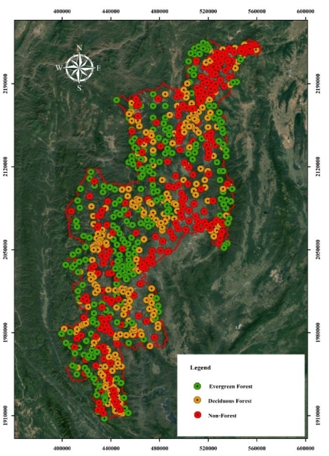
Results: The feature selection process successfully refined the dataset to an optimal subset of 12 non-redundant variables. The analysis revealed that topographic features were the most influential factors governing the model's predictive capability. Specifically, elevation was dominance the ranking with the highest importance score (629.27), followed by slope (492.16). Among the spectral predictors, the shadow index (SI) (215.45) and the Green Normalized Difference Vegetation Index (GNDVI) (184.90) proved to be the most critical variables, as they effectively captured the complexities of canopy structures and mitigated topographic shadow effects during the dry season. The developed RF model demonstrated exceptional performance, achieving a high Out-of-Bag (OOB) accuracy of 90.30%. When evaluated against the independent testing set, the model yielded an Overall Accuracy of 95.92% and a Kappa coefficient of 0.94. Class-specific performance analysis indicated that the non-forest class achieved the highest accuracy (Producer’s Accuracy 97.92%, User’s Accuracy 100%), followed by evergreen forest (Producer’s Accuracy 94.12%, User’s Accuracy 96.00%), and deciduous forest (Producer’s Accuracy 95.83%, User’s Accuracy 92.00%). The final spatial map revealed that deciduous forests cover approximately 48.70% (10,779.68 km2) of the province, predominantly distributed in foothills and mid-elevation zones, while evergreen forests account for 32.37% (7,164.34 km2), densely dominating the higher mountain ranges, which perfectly aligns with highland forest ecology principles. However, spatial verification identified specific limitations. Minor misclassifications were observed within ecological transition zones (ecotones) at elevations between 800 and 1,150 meters due to highly mixed forest structures. Additionally, spectral confusion occurred in agricultural areas containing perennial, long-living fruit orchards (e.g., longan and orange orchards), which maintain permanent green canopies that closely resemble the spectral signatures of natural evergreen forests.
Conclusion: This study demonstrates that applying a RF algorithm with multi-temporal Sentinel-2 imagery on a cloud computing platform provides a highly robust, cutting-edge tool for mapping complex forest ecosystems in mountainous regions. Empirical findings confirm that elevation serves as the most important ecological boundary for forest classification in northern Thailand. The resulting high-precision classification map serves as a vital spatial database for accurately delineating wildfire risk zones and supporting targeted natural resource management. For further enhance model accuracy in future research, it is highly recommended to refine the non-forest class by explicitly separating perennial fruit orchards into distinct sub-categories. Furthermore, incorporating Synthetic Aperture Radar (Sentinel-1 SAR) data or employing advanced texture analysis should be strongly considered to improve the differentiation of physical vegetation structures across complex landscapes.
Downloads
References
Belgiu, M., & L. Dragut. 2016. Random forest in remote sensing: A review of applications and future directions. ISPRS Journal of Photogrammetry and Remote Sensing 114: 24-31. https://doi.org/10.1016/j.isprsjprs.2016.01.011
Bihari, E., Dyson, K., Johnston, K., dela Torre, D. M. G., Chaiyana, A., Tenneson, K., Sittirin, W., Poortinga, A., Tanpipat, V., Wanthongchai, K., Kunlamai, T., Dalton, E., Saisaward, C., Tornorsam, M., Ganz, D., & Saah, D. 2025. Modeling Seasonal Fire Probability in Thailand: A Machine Learning Approach Using Multiyear Remote Sensing Data. Remote Sensing 17(19), 3378. https://doi.org/10.3390/rs17193378
Breiman, L. 2001. Random forests. Machine Learning 45(1): 5-32. https://doi.org/10.1023/A:1010933404324
Cheng, K., & J. Wang. 2019. Forest-type classification using time-weighted dynamic time warping analysis in mountain areas: A case study in southern China. Forests 10(11): 1040. https://doi.org/10.3390/f10111040
Congalton, R. G., & K. Green. 2019. Assessing the accuracy of remotely sensed data: Principles and practices (3rd ed.). CRC Press. https://doi.org/10.1201/9780429052729
Cutler, D. R., T. C. Edwards, K. H. Beard, A. Cutler, K. T. Hess, J. Gibson, & J. J. Lawler. 2007. Random forests for classification in ecology. Ecology 88(11): 2783-2792. https://doi.org/10.1890/07-0539.1
Department of National Parks, Wildlife and Plant Conservation. 2022. Forest Statistics. Available source: https://portal.dnp.go.th/Content/statistics?contentId=28811. (Accessed: February 6, 2026).
Dormann, C. F., J. Elith, S. Bacher, C. Buchmann, G. Carl, G. Carré, J. R. G. Marquéz, B. Gruber, B. Lafourcade, P. J. Leitão, T. Münkemüller, C. McClean, P. E. Osborne, B. Reineking, B. Schröder, A. K. Skidmore, D. Zurell, & S. Lautenbach. 2013. Collinearity: a review of methods to deal with it and a simulation study evaluating their performance. Ecography 36(1): 27-46. https://doi.org/10.1111/j.1600-0587.2012.07348.x
Forest Land Management Bureau. 2025. Forest area data project 2024. Royal Forest Department. (in Thai)
Forkuor, G., K. Dimobe, I. Serme, & J. E. Tondoh. 2018. Landsat-8 vs. Sentinel-2: Examining the added value of Sentinel-2's red-edge bands to land-use and land-cover mapping in Burkina Faso. GIScience & Remote Sensing 55(3): 331-354. https://doi.org/10.1080/15481603.2017.1370169
Gislason, P. O., Benediktsson, J. A., & Sveinsson, J. R. 2006. Random forests for land cover classification. Pattern Recognition Letters 27(4): 294-300. https://doi.org/10.1016/j.patrec.2005.08.011
Gitelson, A. A., Y. J. Kaufman, & M. N. Merzlyak. 1996. Use of a green channel in remote sensing of global vegetation from EOS-MODIS. Remote Sensing of Environment 58(3): 289-298. https://doi.org/10.1016/S0034-4257(96)00072-7
Gorelick, N., M. Hancher, M. Dixon, S. Ilyushchenko, D. Thau, & R. Moore. 2017. Google earth engine: Planetary-scale geospatial analysis for everyone. Remote Sensing of Environment 202: 18-27. https://doi.org/10.1016/j.rse.2017.06.031
Hermhuk, S., A. Chaiyes, S. Thinkampheang, N. Danrad, & D. Marod. 2020. Land use and above-ground biomass changes in a mountain ecosystem, northern Thailand. Journal of Forestry Research 37(5): 1733-1742. https://doi.org/10.1007/s11676-019-00924-x
Jensen, J. R. 2015. Introductory digital image processing: A remote sensing perspective (4th ed.). Pearson Education.
Kamyo, T., D. Marod, S. Pattanakiat, & L. Asanok. 2025. Valuation of potential and realized ecosystem services based on land use data in Northern Thailand. Land 14(3): 529. https://doi.org/10.3390/land14030529
Kawamura, M., S. Jayamana, & Y. Tsujiko. 1996. Relation between social and environmental conditions in Colombo Sri Lanka and the urban index estimated by satellite remote sensing data. International Archives of Photogrammetry and Remote Sensing 31: 321-326.
Khamyong, S., A. M. Lykke, D. Seramethakun, & A. S. Barfod. 2004. Species composition and vegetation structure of an upper montane forest at the summit of Doi Inthanon, Thailand. Nordic Journal of Botany 24(1): 73-96. https://doi.org/10.1111/j.1756-1051.2003.tb00371.x
Khongseng, P. 2017. Land use and land cover classification of Phuket province from Landsat 8 satellite imagery using phenological properties (Master's thesis). Prince of Songkla University. (in Thai)
Kruasilp, J., Pattanakiat, S., Phutthai, T., Vardhanabindu, P., & Nakmuenwai, P. 2023. Evaluation of Land Use Land Cover Changes in Nan Province, Thailand, Using Multi-Sensor Satellite Data and Google Earth Engine. Environment and Natural Resources Journal 21(2): 186-197. https://doi.org/10.32526/ennrj/21/202200200
McFeeters, S. K. 1996. The use of the Normalized Difference Water Index (NDWI) in the delineation of open water features. International Journal of Remote Sensing 17(7): 1425-1432. https://doi.org/10.1080/01431169608948714
Rikimaru, A. 1997. Landsat TM data processing guide for forest canopy density mapping and monitoring model. ITTO Workshop on Utilization of Remote Sensing in Site Assessment and Planning for Logged-over Forests, Bangkok, Thailand.
Royal Forest Department. 2023. Forestry statistics 2022. Royal Forest Department, Ministry of Natural Resources and Environment. (in Thai)
Royal Irrigation Department. 2020. Provincial River Basin Development Master Plan Report: Chiang Mai Province. Project Management Office, Royal Irrigation Department. (in Thai)
Subcommittee on Drafting National Forest Policy and National Forest Development Master Plan. 2020. National forest policy. National Forest Policy Committee. (in Thai)
Talukdar, S., F. Ahmad, & H. Hashim. 2024. Forest fire in Thailand: Spatio-temporal distribution and future risk identification. Natural Hazards Research 4(2): 87-96. https://doi.org/10.1016/j.nhres.2023.09.002
Thai Meteorological Department. 2024. Annual Mean Temperature in Thailand. Available source: https://www.tmd.go.th/en/ClimateChart/annual-mean-temperature-in-thailand. (Accessed: February 6, 2026).
Thammanu, S., D. Marod, H. Han, N. Bhusal, L. Asanok, P. Ketdee, N. Gaewsingha, S. Lee, & J. Chung. 2021. The influence of environmental factors on species composition and distribution in a community forest in Northern Thailand. Journal of Forestry Research 32: 649-662. https://doi.org/10.1007/s11676-020-01239-y
Worachairungreung, M., Kulpanich, N., Yodsuk, P., Ngansakul, P., Thanakunwutthirot, K., & Hemwan, P. (2024). Using a Logistic Regression Model to Examine the Variables Influencing Changes in Northern Thailand's Forest Cover and Comparing Machine Learning Algorithms. Forests, 15(6), 981. https://doi.org/10.3390/f15060981
Yatar, C., S. Thinkampheang, S. Sungkaew, C. Wachrinrat, L. Asanok, T. Kamyo, S. Hermhuk, P. Kachina, J. Thongsawi, W. Phumphuang, A. Yarnvudhi, S. Waengsoyhorn, S. Cheysawat, & D. Marod. 2024. The dynamics of deciduous dipterocarp forest in relation to climate variability in the Sakaerat Biosphere Reserve, Northeastern Thailand. Biodiversitas Journal of Biological Diversity 25(7): 3088-3098. https://doi.org/10.13057/biodiv/d250730
Yarnvudhi, A., S. Sungkaew, S. Hermhuk, P. Sunthornhao, & S. Onprom, S. 2016. Plant diversity and utilization on ethnobotany of local people at Hmong Doi Pui village in Doi Suthep-Pui national park, Chiang Mai Province. Thai Journal of Forestry 35(3): 136-146. (in Thai)
Zhu, X., & D. Liu. 2014. Accurate mapping of forest types using dense seasonal Landsat time-series. ISPRS Journal of Photogrammetry and Remote Sensing 96: 1-11. https://doi.org/10.1016/j.isprsjprs.2014.06.012
Downloads
Published
Issue
Section