
การประเมินสภาพน้ำท่วมด้วยแบบจำลอง HEC-RAS กรณีศึกษาพื้นที่จังหวัดสุราษฎร์ธานี | Flood Assessment Using HEC-RAS Model: A Case Study of Surat Thani Province
Article Sidebar
Main Article Content
Abstract
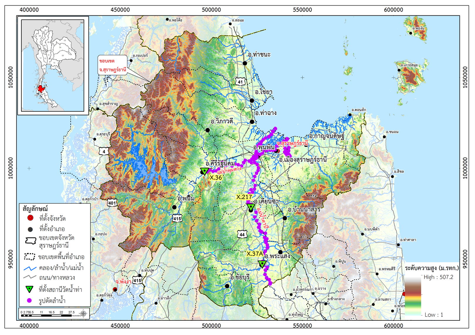
Surat Thani province usually confronts flood problem almost every year. In some years,
there are several floods which cause a lot of damages at a time due to flooding plain areas and waterways. Most steams of the whole province and the rivers are shallow causing insufficient drainage capacity. The objective of this research is to analyze the drainage potential in Surat Thani Province and to assess the flooding area caused by overflows from the Tapee-Pumduang river at the return periods of 2, 5, 10 and 25 years, respectively using HEC-RAS model. Calibration results of one-dimensional model in Tapee river were given by varying Roughness Coefficients (n) of the river and using flow simulation carried out from X.37A (Baan Yaan Din Daeng gauging station) to X.217 (Baan Kian Sa gauging station). The results showed that when the discharge was more than 400 m3/s at n = 0.045, and the relationship between discharge and water level corresponds to the Rating Curve of X.217 (Baan Kian Sa gauging station). The validation of model was performed in comparison with the observation data in 2018. The validation values, R-squared (R2), were 0.956 and the Nash-Sutcliffe Efficiency (NSE) value was 0.811. The study results showed that the maximum flow rates of each cross section for drainage were in the range of 585 to 1,700 m3/s. The maximum water level varied from 1.30 to 2.50 m. The longest flooding time was 3-7 days. Under constant flow conditions, the analysis for determining flooded areas showed that the flooded areas caused by overflows at the return periods of 2, 5, 10 and 25 years were 549.82, 594.46, 615.22 and 639.74 km2, respectively.
บทคัดย่อ
จังหวัดสุราษฎร์ธานี เป็นจังหวัดที่ประสบกับปัญหาน้ำท่วม เกือบทุกปี และในบางปีเกิด น้ำท่วมหลายครั้ง และแต่ละครั้งสร้างความเสียหายจำนวนมาก เนื่องจากพื้นที่จังหวัด เป็นที่ราบลุ่ม เป็นทางน้ำไหลผ่านของลำน้ำเกือบทั้งจังหวัด และแม่น้ำตื้นเขิน มีความสามารถระบายน้ำไม่เพียงพอ วัตถุประสงค์ของการวิจัยนี้ เพื่อวิเคราะห์ศักยภาพการระบายน้ำในพื้นที่จังหวัดสุราษฎร์ธานี และเพื่อประเมินพื้นที่น้ำท่วมที่เกิดขึ้นจากการไหลล้นตลิ่งออกจากแม่น้ำตาปี-พุมดวง ณ คาบการเกิดซ้ำจากปริมาณน้ำท่า 2 ปี, 5 ปี, 10 ปี และ 25 ปี ด้วยแบบจำลอง HEC-RAS ผลการปรับเทียบแบบจำลองการไหลหนึ่งมิติในแม่น้ำตาปี ได้ใช้วิธีการแปรค่าสัมประสิทธิ์ความขรุขระ (n) ของลำน้ำ โดยการจำลองการไหล จากสถานีวัดระดับน้ำ X.37A บ้านย่านดินแดง จนถึงสถานีวัดระดับน้ำ X.217 บ้านเคียนซา ผลการปรับเทียบพบว่า เมื่อมีปริมาณน้ำมากกว่า 400 ลบ.ม./วินาที ค่า n ที่ 0.045 จะทำให้ได้ค่าความสัมพันธ์ระหว่างปริมาณน้ำและระดับน้ำที่สอดคล้องกับ Rating Curve ของสถานีวัดระดับน้ำ X.217 บ้านเคียนซา และสอบเทียบแบบจำลองใน พ.ศ 2561 มีค่า R2 เท่ากับ 0.956 และค่า NSE เท่ากับ 0.811 ผลการศึกษาพบว่า สำหรับศักยภาพการระบายน้ำได้ค่าอัตราการไหลสูงสุดสำหรับแต่ละหน้าตัดการไหลอยู่ในช่วง 585 ถึง 1,700 ลบ.ม./วินาที ค่าระดับน้ำสูงสุด 1.30 ถึง 2.50 เมตร และระยะเวลาน้ำท่วมสูงสุด 3-7 วัน สำหรับการวิเคราะห์หาพื้นที่น้ำท่วมภายใต้เงื่อนไขการไหลคงที่ พบว่า พื้นที่น้ำท่วมที่เกิดจากการเอ่อล้นตลิ่ง ณ คาบการเกิดซ้ำ 2 ปี, 5 ปี, 10 ปี และ 25 ปี เท่ากับ 549.82, 594.46, 615.22 และ 639.74 ตร.กม. ตามลำดับ
Downloads
Article Details
References
กรมชลประทาน. (2563).โครงการศึกษาความเหมาะสมและวิเคราะห์ผลกระทบสิ่งแวดล้อม การพัฒนาระบบชลประทานบริเวณพื้นที่ท้ายเขื่อนรัชชประภา จังหวัดสุราษฎร์ธานี. (น.48). กรุงเทพฯ.
กรมชลประทาน. (2564). Return Period. สืบค้นเมื่อวันที่ 10 มีนาคม 2564, จากhttps://hydro-8.com/
สถาบันสารสนเทศทรัพยากรน้ำ(องค์การมหาชน). (2554).บันทึกเหตุการณ์น้ำท่วมบริเวณภาคใต้ 23 มีนาคม - 3 เมษายน 2554. สืบค้นเมื่อวันที่ 5 มีนาคม 2564, จากhttps://tiwrm.hii.or.th/current/floodsouth_mar54.html
สำนักอุทกและการระบายน้ำ. (2553) คู่มือการประเมินค่าปริมาณการไหลของน้ำด้วยวิธี Manning’s formula. (น.8-9) กรุงเทพฯ.
Cameron T. Ackerman, P.E. (2011). HEC-GeoRAS GIS Tool for Support of HEC-RAS using ArcGIS. California: US Army Corp of Engineers.
Chow, V. T. Maidment, D. R. & Mays, L. W. (1988). Applied hydrology (4nd ed.). McGraw-Hill: New York.
Gary W, Brunner. (2016). HEC-RAS River Analysis System Hydraulics Reference Manual. California: US Army Corp of Engineers.
John C. Warner, Gary W. Brunner, Brent C. Wolfe, and Steven S. Piper. (2009). HEC-RAS River Analysis System Applications Guide. California: US Army Corp of Engineers.
Sangthong, P. & Kosa, P. (2014). Estimation of Streamflow using SWAT: A Case Study of Upper Lam Phra Phloeng River Basin.Technical Education. Journal King Mongkut’s University of Technology North Bangkok, 5(2): 165-176.
ThairathOnline. (2011). น้ำท่วมสุราษฎร์ธานี ยังวิกฤต อ.พุนพิน กลายเป็นทะเล. Retrieved March,15 2021, from https://www.thairath.co.th/content/16065
US Army Crops of Engineerings. (2016). HEC-RAS 2D Modeling User’s Manual version 5. USA.