Spatiotemporal Assessment of Plant Community in Mixed Deciduous Forest, Mahidol University (Kanchanaburi Campus)
DOI:
https://doi.org/10.34044/tferj.2026.10.1.6520Keywords:
Mixed deciduous forest, spatiotemporal, unmanned aerial vehicleAbstract
Background and Objectives: Forests are vital natural resources that support living organisms and serve as key mechanisms for maintaining ecological stability and balance, particularly through their role in carbon sequestration and storage. Global climate change and the reduction of forest areas due to human activities have made monitoring and assessing forest resources critically important. Mahidol University, Kanchanaburi Campus, located in Sai Yok District, Kanchanaburi Province, encompasses approximately 6,500 rai of land, most of which consists of mixed deciduous forest on karst topography—a highly unique ecosystem suitable for sustainable conservation. The main objectives of this study are to: (1) assess the spatiotemporal changes in plant communities, (2) evaluate changes in plant community structure and growth of mixed deciduous forest species over a 10-year period, and (3) develop spatial data layers of the mixed deciduous forest within Mahidol University, Kanchanaburi Campus.
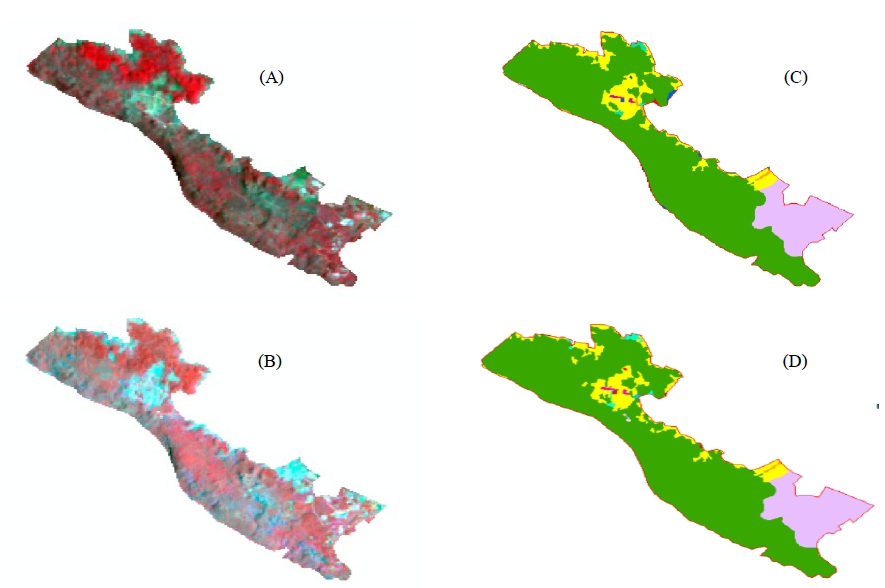
Methodology: This study compared historical data on plant community structure (plant census) from 2014 (B.E. 2557) with current data from 2024 (B.E. 2567). Random sample plots measuring 40 m × 40 m were established within permanent study plots to collect information on species diversity and quantitative plant characteristics, such as species identity and diameter at breast height (DBH). These data were used to calculate key quantitative attributes of the plant community, including the Shannon–Wiener Diversity Index and the Importance Value Index (IVI), which was derived from relative density, relative dominance, and relative frequency to assess the status of the vegetation. Tree growth was evaluated by comparing the mean DBH of 34 previously recorded trees over the 10-year period, with statistical significance tested using a paired t-test. For assessing spatiotemporal changes, Landsat-8 satellite imagery from March 2014 and March 2024, representing the dry season, was used to classify land-use patterns. Geoinformatics technologies were employed to interpret and analyze the data to estimate land-use proportions. Differences in overall land-use change were analyzed using the Wilcoxon Signed-Rank Test. In addition, unmanned aerial vehicles (UAVs) were utilized to capture aerial photographs and generate three-dimensional (3D) forest structure models. These datasets serve as a foundation for evaluating forest structural attributes such as canopy height and density.
Results: Spatiotemporal Changes: The assessment over a 10-year period revealed that the mixed deciduous forest area (F2) increased by 76,640 m2, representing 0.72% of the total area. However, statistical analysis using the Wilcoxon Signed-Rank Test indicated that overall land-use changes were not statistically significant (p-value = 0.674). The observed increase in forest area reflects the effectiveness of land management under the university’s supervision, where there has been no agricultural encroachment, unlike in other community forests on karst landscapes in Kanchanaburi Province, allowing for natural forest regeneration. Plant Community Structure and Diversity: The survey identified 37 tree species within the sample plots. The Shannon–Wiener Diversity Index was 2.94, indicating relatively low species diversity. The species with the highest Importance Value Index (IVI) was Grewia eriocarpa (52.67), which serves as a dominant species in this area. The top five species in terms of IVI were Grewia eriocarpa, Croton roxburghii, Millettia brandisiana, Sterculia pexa, and Dalbergia oliveri. Tree Growth: Comparison of 34 previously recorded trees showed an average increase in diameter at breast height (DBH) of 8.12 cm over the 10-year period, corresponding to an average annual growth rate of 0.812 cm/year. Paired t-test results confirmed a statistically significant difference in mean DBH between 2014 (B.E. 2557) and 2024 (B.E. 2567) (p-value<0.001) indicating continuous tree growth within the area. The species with the highest growth was Vitex quinata, followed by Grewia eriocarpa.
Conclusions: This spatiotemporal study demonstrates that the mixed deciduous forest on karst topography at Mahidol University, Kanchanaburi Campus, is undergoing continuous recovery. A comparison of forest structure data over the 10-year period confirmed that the original trees exhibited statistically significant growth in diameter at breast height (DBH), reflecting positive outcomes from successful land management policies that effectively prevented encroachment. However, despite this encouraging structural recovery, species diversity within the plant community remains low. The data on spatiotemporal changes and forest structure thus provide a valuable baseline tool for the university to plan forest resource management and to assess the potential for sustainable carbon sequestration.
Downloads
References
Baker, T. R., O. L. Phillips, Y. Malhi, S. Almeida, L. Arroyo, A. Di Fiore, T. Erwin, T. J. Killeen, S. G. Laurance, W. F. Laurance, S. L. Lewis, J. Lloyd, A. Monteagudo, D. A. Neill, S. Patiño, N. C. A. Pitman, J. N. M. Silva & R. Vásquez Martínez. 2004. Variation in wood density determines spatial patterns in Amazonian forest biomass. Global Change Biology 10: 545–562. https://doi.org/10.1111/j.1365-2486.2004.00751.x DOI: https://doi.org/10.1111/j.1365-2486.2004.00751.x
Chave, J., R. Condit, H. C. Muller-Landau, S. C. Thomas, P. S. Ashton, S. Bunyavejchewin, L. L. Co, H. S. Dattaraja, S. J. Davies, S Esufali, C. E. N. Ewango, K. J. Feeley, R. B. Foster, N. Gunatilleke, S. Gunatilleke, P. Hall, T. B. Hart, C. Hernández, S. P. Hubbell, A. Itoh, S. Kiratiprayoon, J. V. LaFrankie, S. L. de Lao, J. Makana, M. N. S. Noor, A. R. Kassim, C. Samper, R. Sukumar, H. S. Suresh, S. Tan, J. Thompson, M. D. C. Tongco, R. Valencia, M. Vallejo, G. Villa, T. Yamakura, J. K. Zimmerman & E. C. Losos. 2008. Assessing evidence for a pervasive alteration in tropical tree communities. PLoS Biology 6(3): e45. https://doi.org/10.1371/journal.pbio.0060045 DOI: https://doi.org/10.1371/journal.pbio.0060045
Chazdon, R.L. 2014. Socond Growth: The Promise of Tropical Forest Regeneration. University of Chicago Press, Chicago. DOI: https://doi.org/10.7208/chicago/9780226118109.001.0001
Curtis, R. O. & D. D. Marshall. 2005. Permanent-plot Procedures for Silvicultural and Yield Research. General Technical Report PNW-GTR-634. Portland, OR: U.S. Department of Agriculture, Forest Service. DOI: https://doi.org/10.2737/PNW-GTR-634
Curtis, P. G., C. M. Slay, N. L. Harris, A. Tyukavina, & M. C. Hansen. 2018. Classifying drivers of global forest loss. Science 361(6407): 1108–1111. 10.1126/science.aau3445 DOI: https://doi.org/10.1126/science.aau3445
Forest Restoration Research Unit (FORRU). 2005. How to Plant a Forest: The Principles and Practice of Restoring Tropical Forests. Department of Biology, Faculty of Science, Chiang Mai University.
Geist, H. J. & E. F. Lambin. 2002. Proximate causes and underlying driving forces of tropical deforestation. BioScience 52(2): 143–150. https://doi.org/10.1641/0006-3568(2002)052[0143:PCAUDF]2.0.CO;2 DOI: https://doi.org/10.1641/0006-3568(2002)052[0143:PCAUDF]2.0.CO;2
Geldmann, J., A. Manica, N. D. Burgess, L. Coad & A. Balmford. 2019. A global-level assessment of the effectiveness of protected areas. Biological Conservation 227: 292–301. https://doi.org/10.1073/pnas.1908221116 DOI: https://doi.org/10.1073/pnas.1908221116
GISTDA. 2009. Textbook of Space Technology and Geo-Informatics. Nonthaburi: Amarin Printing and Publishing Public Co.
Joppa, L. N. & A. Pfaff. 2011. Global protected area impacts. Proceedings of the Royal Society B 278:1633–1638. https://doi.org/10.1098/rspb.2010.1713 DOI: https://doi.org/10.1098/rspb.2010.1713
King, D.A., S. J. Davies, & S. Tan. 2006. Tree growth is related to light interception and wood density. Functional Ecology 19: 445-453. https://doi.org/10.1111/j.1365-2435.2005.00982.x DOI: https://doi.org/10.1111/j.1365-2435.2005.00982.x
Lambin, E. F., H. J. Geist & E. Lepers. 2003. Dynamics of land-use and land-cover change. Annual Review of Environment and Resources 28: 205–241. https://doi.org/10.1146/annurev.energy.28.050302.105459 DOI: https://doi.org/10.1146/annurev.energy.28.050302.105459
Poorter, L., F. Bongers, T. M. Aide, A. M. A. Zambrono, P. Balvanera, J. M. Becknell. V. Boukili, P. H. S. Brancalion, E. N. Broadbent, R. L. Chazdon, D. Claven, J. S. de Almeida-Cortez, G. A. L. Cabral, B. H. J. de Jong, J. S. Denslow, et al. 2016. Biomass resilience of Neotropical secondary forests. Nature 530: 211–214. https://doi.org/10.1038/nature16512 DOI: https://doi.org/10.1038/nature16512
Kamyo, T., D. Marod, S. Pattanakiat, S. Suksawang & S. Panuthai. 2016. Land cover changes in tropical seasonal forests at Mae Klong head watershed, Kanchanaburi province, Thailand. Maejo International Journal of Science and Technology 10(03): 304–312.
Krebs, C. J., 1972. Ecology: The Experimental Analysis of Distribution and Abundance. New York: Harper & Row.
Marod, D., & U. Kutintara. 2009. Forest Ecology. Faculty of Forestry, Kasetsart University. (in Thai)
Marod, D., U. Kutintara, H. Tanaka & T. Nakashizuka. 2002. The effects of drought and fire on seed and seedling dynamics in a tropical seasonal forest in Thailand. Plant Ecology 161: 41–57. https://doi.org/10.1023/A:1020372401313 DOI: https://doi.org/10.1023/A:1020372401313
Mahidol University, Kanchanaburi Campus. 2022. History. Mahidol University, Kanchanaburi Campus. Available source:https://ka.mahidol.ac.th/th/facilities/digital-herbarium/ (Accessed; September 20, 2025)
Ogawa, H., K. Yoda, K. Ogino & T. Kira. 1965. Comparative ecological studies on three main types of forest vegetation in Thailand II. Plant biomass. Nature and Life in Southeast Asia 4: 49–80.
Plant of the World Online. 2023. Grewia eriocarpa Juss. Available source: https://powo.science.kew.org/taxon/urn:lsid:ipni.org:names:834215-1. (Accessed; September 20, 2025)
Sriboonruang, K., N. Phitakhtansakul & Phitakhtansakul, P. 2018. Patterns and trends of land use change in community forest areas of limestone mountains, Kanchanaburi Province. Sukhothai Thammathirat Journal 31(2): 90–109. https://so05.tcithaijo.org/index.php/stouj/article/view/206769
Pattanakiat, S. 2003. Geographic Information Systems in Ecology and Environment. Bangkok: United Production.
Smitinand, T. 2014. Thai Plant Names (Revised Edition). Bangkok: Department of National Parks, Wildlife and Plant Conservation.
Thamarat, P. & N. Pakorn. 2014. Diversity of Herbaceous Plants Growing on Rocks in Mixed Deciduous Forest at Mahidol University, Kanchanaburi Campus. Office of the Higher Education Commission, Research Promotion Project for Higher Education and National Research University Development.
UNEP. 2010. Annual Report. UN Environment Programme. Available source: https://www.unep.org/resources/annual-report/unep-2009-annual-report (Accessed: October 15, 2025)
Wichan, P. 2022. Ecological Study of Forest Areas under the Royal Initiative Natural Science Park Project, Suan Phueng Subdistrict, Suan Phueng District, Ratchaburi Province. Available source: https://www.psproject.org/ (Accessed: September 20, 2024.)
Whitmore, T.C. 1998. An Introduction to Tropical Rain Forests. Oxford: Oxford University Press. DOI: https://doi.org/10.1093/oso/9780198501480.001.0001
Downloads
Published
Issue
Section